Rising from the Ashes: Toronto's Development After the Great Fire of 1904

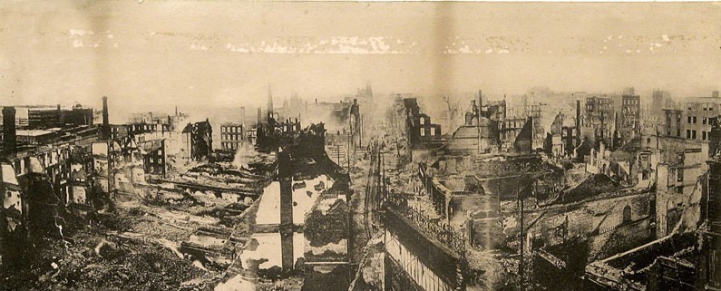
The great fire of Toronto on April 19, 1904, reportedly began at the E. & S. Currie neckwear factory located at 58-60 Wellington St. W. (currently the location of the TD Bank Tower at 66 Wellington W), and rapidly escalated into a city-wide disaster. The fire was first noticed at 8:04 p.m. when flames were seen at the factory. Despite the efforts of the fire chief and crews, the fire quickly spiraled out of control due to a combination of high winds and inadequate water pressure.
The inferno engulfed the city's major industrial area, which at the time included factories, warehouses, and printing shops, specifically around the area of King and Bay Streets, the area that we now refer to as Toronto's financial district. Approximately 100 buildings were destroyed, and about 220 businesses were affected, leaving significant impact on the city's infrastructure and economy.
Survey plans would have played a vital role in Toronto’s rebuilding process in the aftermath of the fire. Using existing plans, Surveyors could create new survey plans that represented the fabric of the land and expedite the rebuilding process.
Here, we present several examples of survey plans that would have contributed in the redevelopment process:
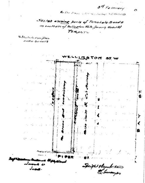
Brown Brothers and Rolph Smith & Company –
Situated at 53 & 55 Wellington Street West, currently known as the Royal Bank Plaza at 200 Bay Street, these premises occupied the southwest corner of Wellington and Bay Streets. These companies were directly across the street from where the fire reportedly originated.
 |
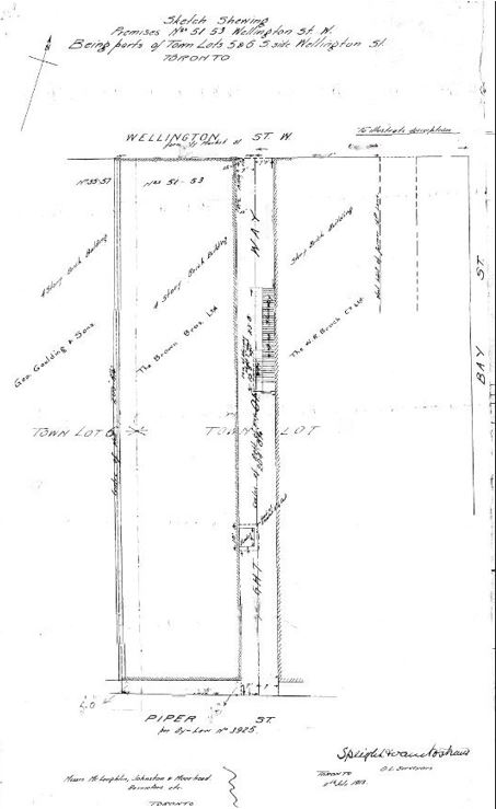 |
| Speight, van Nostrand & Gibson Limited - Historic; Year:1890 (14 Years before the fire) Image Courtesy of Krcmar Surveyors | Speight, van Nostrand & Gibson Limited - Historic; Year:1913 (9 Years after the fire) Image Courtesy of Krcmar Surveyors |
The 1890 and 1913 survey plans display remarkable similarities, illustrating consistency in the fabric of the land despite the destruction of buildings. By referencing older plans, surveyors can accurately locate ground markers utilizing existing measurements from the remnants of building foundations. This process aids in correctly subdividing the land for redevelopment and restoring business districts and communal areas to their intended configurations.
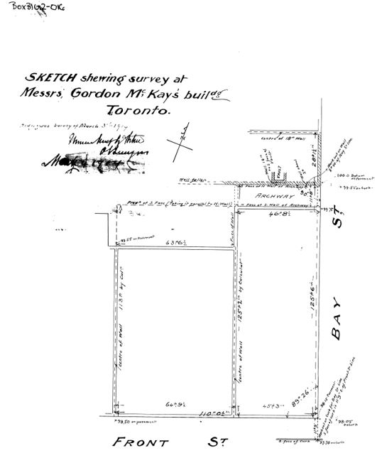
Gordon Mackay Building
A retail store situated at 48 & 50 Front Street West, these premises occupied the northwest corner of Front and Bay Street and also forms the current Royal Bank Plaza at 200 Bay Street.
 |
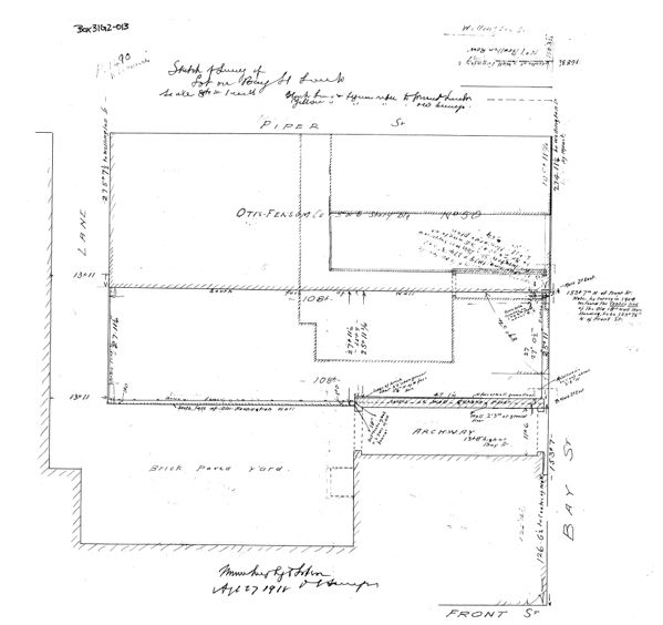 |
| Krcmar Surveyors Ltd - Legal Survey ; Year: May 1904 | Krcmar Surveyors Ltd - Legal Survey; Year:1918 |
The 1918 survey references the 1904 survey where the centerline of an old wall was identified. This example illustrates the role historical survey plans play in creating modern plans, as well as demonstrating how evidence from historic survey plans aid in validating land information.
Barber and Ellis Building
Formerly a stationery company located at 43-49 Bay Street, now occupied by the TD Canada Trust Tower at the modern-day address, 161 Bay Street; It is positioned on the northeast corner of Front and Bay Streets.
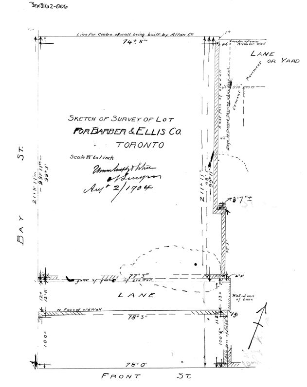
Courtesy of Krcmar Surveyors Ltd.
This survey plan, from Aug 1904, demonstrates the rapid pace at which surveyors were able to recreate a visual for this portion of land. The availability of historical surveys significantly streamlines the land subdivision process, and potentially averts any legal disputes. Preserving these plans is not only historically valuable but also crucial in cases involving legal ownership disputes
The survey plans showcased here illustrate the importance of historic survey plans in redevelopment. They provide precise layouts of land and structures, streamline the planning process, and help identify markers and foundations. Additionally, these plans verify land ownership and ensure that redevelopment honors the area's historical integrity, making them vital for effective urban planning and recovery.


Protect Your Boundaries Inc. is a licensed member of the Association of Ontario Land Surveyors, and is entitled to provide cadastral surveying services to the public of the Province of Ontario in accordance with the provisions of the Surveyors Act R.S.O. 1990, Chapter S29.