Tides, Tracks and Towers: Rebuilding Toronto’s Harbourfront

Every year, millions of visitors head to downtown Toronto to experience some of its most iconic landmarks, the CN Tower and Rogers Centre. Whether to cheer on their favourite team, ride the tower's glass elevator 1,136 feet into the sky, or simply observe the architecture from the ground, there is no denying the energy of this lively neighbourhood.
Just steps away, to the tower's south, lies Roundhouse Park — a unique public space where Toronto’s past meets its present. Here, the restored John Street Roundhouse is home to the Steam Whistle Brewery and the Toronto Railway Museum. These attractions are not just charming places to visit; they are reminders of Toronto’s industrial roots and its once-thriving railway network.
Before the skyscrapers, Towers, and stadiums, this part of the city was dominated by steam engines and railyards — the beating heart of a rapidly expanding city. But even before that, the story of this land runs deep…and watery.
A Different Waterfront
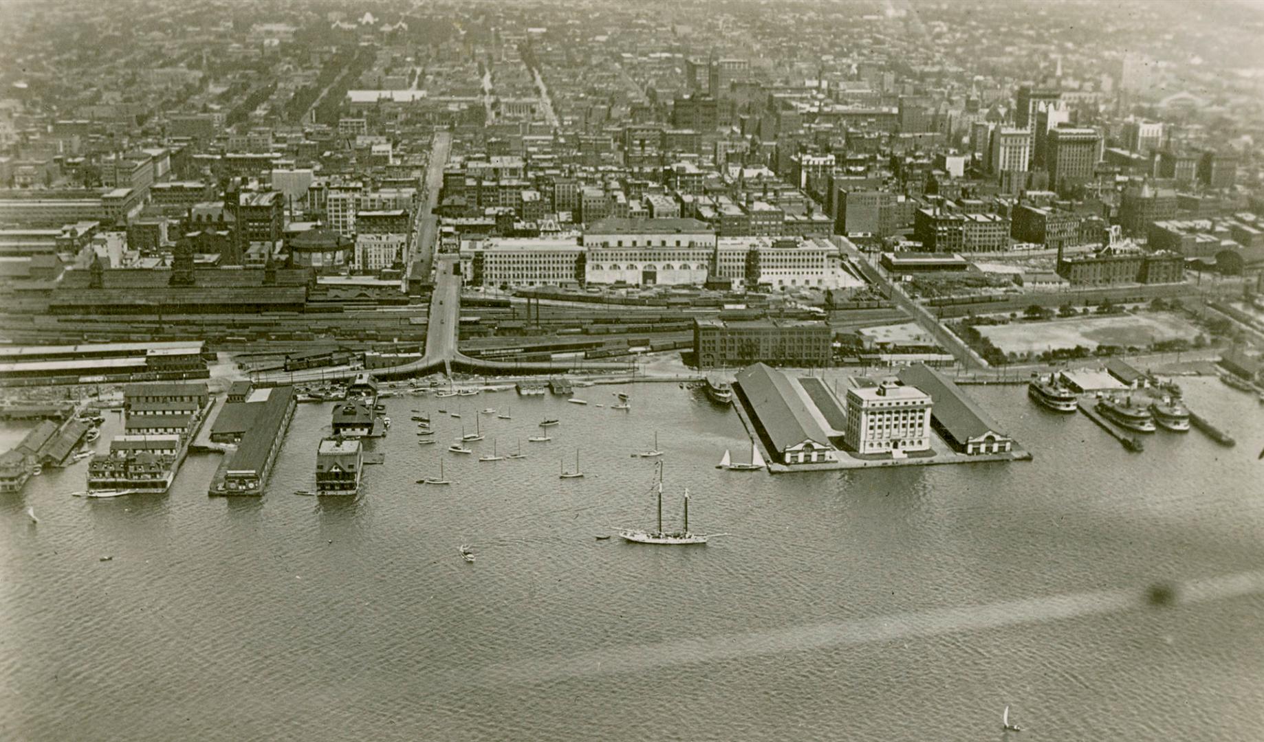
| With all this magnificent architecture and history to consider, you might find it hard to believe that at one point in time, this land on which all the magnificent attractions exist was completely underwater. In the early 1800s, the natural shoreline of Lake Ontario reached as far North as Front Street, meaning our subject land was a bay of marshes, creeks, and a rich ecosystem that was inhabited by Indigenous nations for thousands of years |  |
With all this magnificent architecture and history to consider, you might find it hard to believe that at one point in time, this land on which all the magnificent attractions exist was completely underwater. In the early 1800s, the natural shoreline of Lake Ontario reached as far North as Front Street, meaning our subject land was a bay of marshes, creeks, and a rich ecosystem that was inhabited by Indigenous nations for thousands of years.
Snapshot of a Changing City
This 1917 Plan of Subdivision Illustrating Parts of Waterlots in Toronto Bay offers us a glimpse into what was a very transformative period for the city. Familiar street names like Yonge, Spadina, and Bay
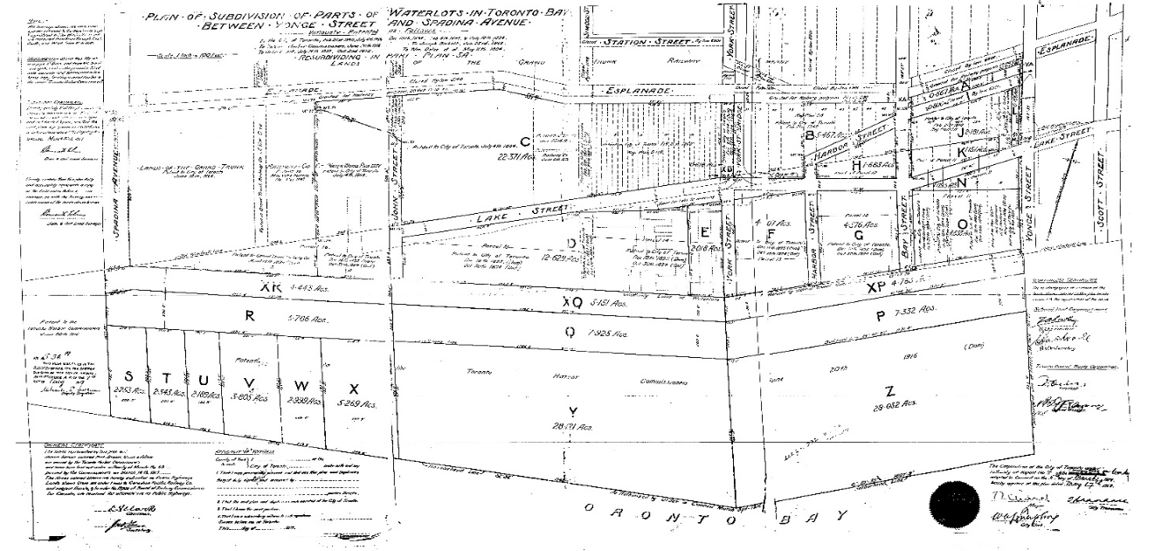
appear on the map, but they’re joined by others that have since faded from the cityscape. Streets such as Lake Street and Harbour Street, which once traced the edge of the shoreline, no longer exist in these locations.
The Esplanade also makes an appearance west of Yonge Street- this is because early concepts of the road designated this road as a public promenade along the harbour. This idea was quickly replaced by railway infrastructure, and any part of the Esplanade West of Yonge Street was replaced or absorbed into the rail system.
Many of the large empty blocks in the south would represent recently infilled land that would go on to host much of the downtown’s major infrastructure.
Why Does This Matter?
Even if surveys or history aren’t typically your thing, it’s hard to ignore the interesting fact that some of Toronto’s most iconic infrastructure was built on land that was once entirely underwater.
Beyond that, historical surveys, such as the one in this article, are sometimes the best connection we have to the past. As well-preserved legal documents, they help reveal lost features such as streets, landmarks and shorelines. They also serve as tangible evidence of the past that once was. Without these historical links, it is easy to forget what was lost in the name of progress.
As Toronto continues to grow and change, it’s important to remember that even the most iconic places have deep, layered histories beneath them—sometimes quite literally. The CN Tower and Rogers Centre may define the skyline today, but the land they stand on has lived many lives. Historic surveys give us a rare chance to look back and see how far we've come. In preserving them, we preserve the story of Toronto itself.
References
Old Toronto Maps. (n.d.). Retrieved from https://oldtorontomaps.blogspot.com/
CN Tower. (n.d.). Land Acknowledgment. Retrieved from https://www.cntower.ca/land-acknowledgment#landacknowledgment
CN Tower. (n.d.). Inspiring by Day. Stellar by Night. Retrieved from https://www.cntower.ca/inspiring-by-day-stellar-by-night
Waterfront Toronto. (n.d.). Central Waterfront. Retrieved from https://www.waterfronttoronto.ca/our-projects/scope-scale/central-waterfront
Image Reference:
Toronto Public Library Digital Archive. (n.d.). Search results: “Toronto Harbour” (1900–1920). Retrieved from https://digitalarchive.tpl.ca/search/Toronto%20Harbour/objects/images?filter=date%3A1900%2C1920&page=5
Krčmar Surveying Ltd. (n.d.). Plan of Subdivision of Parts of Waterlots in Toronto Bay (1917). Krčmar Private Survey Records. Courtesy of Protect Your Boundaries.


Protect Your Boundaries Inc. is a licensed member of the Association of Ontario Land Surveyors, and is entitled to provide cadastral surveying services to the public of the Province of Ontario in accordance with the provisions of the Surveyors Act R.S.O. 1990, Chapter S29.